
- Connard Hogan
- Nov 8, 2025
- 10 min read
Updated: Jan 8
Bottom line: The best laid plans often go astray.

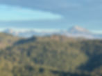
Sunset near Quincy, CA.
Mark R. (once again using the moniker of Wrong-way) and I made a last minute alteration to our hike plan (the section from Horseshoe Meadow to Bishop Pass). Instead, we opted for a stretch of trail in lower elevation, and thus, with less chance of inclement weather, vis-à-vis snow. Wrong-way liked the section between Sierra City, CA (mm 1196.6) and Chester, CA (mm 1332.3).
Note: Though, we opted to hike northbound (NOBO) some days, and southbound (SOBO) some days, I provide the northbound mile-marker designations for consistency, since we're headed northward overall anyway.
And, as per our two-vehicle availability, we anticipated moving our cars as necessary to maximize our one-day hikes, decrease the number of overnights on the trail ... and thus carry less weight (tent, sleeping bags, water, warm weather clothing and food). In addition, we'd have the option to hike northbound or southbound, depending which direction we considered the most advantageous for each section between our positioned vehicles at road junctions (increasing or decreasing elevation, for example). What a plan! Thru-hikers can't do that! Prim8 was all in on the idea, of course.
10/20/25, Monday (Day 0) - Wrong-way and I rendezvoused in Chester, a drive of some 538 miles for me, for an overnight stay there prior to starting our segment hiking. My drive went smoothly and the fall colors of deciduous trees near Lassen National Park were stunning, which helped offset the depressing and seemingly endless burned, blackened pines.
10/21/25, Tuesday (Day 1) - Frost coated my car's windshield in Chester as Wrong-way and Prim8 anticipated beginning our first day's segment hike.
My car positioned at Highway 36/PCT junction (mm 1332.3), we then drove to Humboldt Summit parking area (mm 1312.8) in Wrong-way's car.
Starting our hike at 8:30AM under a cloudless sky and temperature of 36 degrees F, I anticipated feeling chilled as we headed NOBO (northbound), though soon warmed up as per usual from the exertion of hiking.
To my surprise, we came upon the PCT "Halfway Monument" (mm 1320.7). (Due to yearly reroutes, however, the actual halfway point is now estimated to be closer to mile 1325.1.) Though, Wrong-way and I had skipped a considerable section of the PCT from Horseshoe Meadow to here, we nevertheless commemorated our arrival. After all, we fully expected to hike every mile of the trail at some time, regardless.

Prim8 points NOBO from
the PCT Halfway Marker.
I spotted a sticker inside the registration box at the Halfway Monument, and pointed it out to Wrong-way. We both chuckled.
"I go through this every day," I joked to Wrong-way. Prim8 knew exactly what I meant.

Sticker on the registration box
at the PCT Halfway Monument.
Several miles on, we passed two men engaged in trail maintenance. One informed us that the Dixie Fire had consumed about 980,000 acres in 2021. Note: I've since researched that fire and learned it burned for two months, reached a final size of 963,309 acres (that's 1,505 square miles!) and was the second-largest single wildfire in California history at the time.

Wrong-way (Mark) pauses
on the trail. (Note: We were to
see many burned pine trees.)

A view of burned pine forest with
Mt. Lassen (background, near centered).
A better view of Mt.
Lassen from the trail.
Further evidence of a fire.

Evidence of forest regeneration.
We camped near Soldier Creek at mm 1325.4, some 12.6 miles from our start. Then, we munched on cold, dry food. No cooking on the trail for us! We avoided schlepping cooking gear, stove and fuel on the trail. Why carry the weight?
10/22/25, Wednesday (Day 2) - The temperature a bit warmer, and with no frost present at 8:11AM, we continued NOBO in light wind through the remnant of burned pine forest.
I noticed a familiar pain aside the heel of my left foot as we hiked. Sure enough, when I checked later, I discovered a blister.
Dang it, Prim8! I won't forget to grease my feet again.
Once at Highway 36 junction (mm 1332.3), we drove to Belden Town to drop my car, then headed to Humboldt Summit parking area in Wrong-way's RAV4.
10/23/25, Thursday (Day 3) - Under clear sky and in a light, but chilling breeze, we left our car camp at Humboldt Summit at 7:30AM, heading SOBO. Before we started, however, I'd applied a pad to my foot's blistered area, then smeared an ample amount of Vaseline to both feet. (And which I would continue to do daily.)
That should fix it, Prim8.
Low growing brush, from one to one-and-a-half feet high, crowded the trail for several long stretches.
No place to be wearing short pants, Prim8!
At ~mm 1300, a sign informed us of the transition boundary from the Cascade Mountain Range to the Sierra Nevada Mountain Range. Soon after, I concluded the trail condition had worsened when the rounded, smaller pumice stones disappeared, replaced by irregular, jagged ones of various composition that created a greater tripping hazard!
At 6PM, as nightfall approached, and unable to find a nearby designated trail campsite, we discovered a level area aside the trail, large enough for the footprint of Wrong-way's two-man tent (~mm 1296.6?).

Can you spot our
makeshift campsite?
(BTW, we left no discernible
traces of our presence.)
10/24/25, Friday (Day 4) - Breaking camp, we continued SOBO at 7:51AM. Prim8 complained constantly about knee pain as we hiked this 8.6-mile rocky stretch descending nearly 2,600 feet in elevation, though not at a steady grade. Slowed by the agony of painful knees (mine), we arrived at my car in Belden Town (mm 1288.0) at 1:30PM.
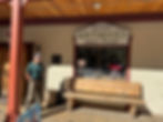
Wrong-way prepares to peruse the
"dubious luxuries" at the Belden
Town Resort Lodge.
After retrieving Mark's car, we discussed various options, revised our plan, then drove both vehicles to a hotel in Chester.
Blame it on age, or poor physical conditioning ... and though I had thoughts of becoming a wuss ... I put up no fuss when Wrong-way had suggested this option. I preferred to blame it on my painful knees! Prim8 wasn't complaining, that's for sure.
10/25/25, Saturday (Day 5) - During an intermittent light rain in Chester, we enjoyed a cooked breakfast at Cravings Restaurant. Sated for the moment, we prepositioned my car at Bucks Lake Road junction (mm 1269.1), then drove Wrong-way's vehicle to Big Creek Road junction (mm 1264.7).
Dressed for rain, our 4.6-mile trek to my car proceeded in relatively dry conditions, though the sky broke open just as we finished our hike.
Great timing, Prim8! "Just in time," I joked with Wrong-way.
We retrieved Mark's RAV4, and made a beeline for the Old Sierra City Hotel, where we secured a room.

Prim8 embraces the Old
Sierra City Hotel as
"Home, Sweet Home."

Restroom sign at Old Sierra
City Hotel, least anyone get
confused.
Wrong-way and I sauntered down the double-lane main street (the only street there that I could discern) to Sorracco's Saloon, less than a hundred yards distance. With a considerable selection of beer and liquor from which to choose, we sampled some of Ron's wares, as we chatted with him and other fellow imbibers.
My selection of a "Kentucky Tangerine Cream" beer hit the spot. Very tasty it was, and Prim8 loved it! That encouraged me to imbibe with a shot of Mary Dowling bourbon ... though I'm not a connoisseur by any means, I just like to experience different things. Wrong-way stuck with beer.
Returned to the Old Sierra City Hotel, we had dinner, then hunkered in for the night.
10/26/25, Sunday (Day 6) - Rain continued throughout the day. (Would've been a misery for us to hike). Anticipating the weather's improvement, we'd positioned Wrong-way's car at a campground (mm 1221) near "A Tree spring". (I kid you not about that name.) One rough patch on the road nearly stymied us altogether, when I had difficulty getting traction over an formation of rock. Persevering, however, I maneuvered my car to the planned trail/campground junction. Then, leaving Wrong-way's car there and on our way out in my car, Wrong-way strategically re-positioned a few rocks, which helped reduce the severity of the said obstacle, and thus, potential damage to my vehicle.
We returned to the Old Sierra City Hotel for another night's stay.
10/27/25, Monday (Day 7) - The rain moved on, and the sky was cloudless, though the roads remained wet and a thin layer of snow covered the ground in scattered patches. In my car, we drove to a jeep road/trail junction (~mm 1208), which Wrong-way referred to as "Packer Lake", though that name didn't appear on the Halfmile PCT notes.
I wrapped my soar, left knee with a stretchy bandage, and we started our hike SOBO about 9:25AM in a temperature of 37 degrees F. An intermittent light breeze kept us cool. Small amounts of snow lay spread across the terrain and on the trail, clearly recording evidence of bear presence, as our day's hike segment ranged above seven-thousand feet.

Evidence of bears in the vicinity.
When we completed our day's hike in Sierra City, Wrong-way and I opted to stay at the Old Sierra City Hotel ... again!
Are we turning into wimps? I wondered. Prim8 liked the idea, however. I concluded that the stretchy bandage worked to reduce my left knee pain, and that hiking uphill might better suit my body.
10/28/25, Tuesday (Day 8) - Up at 6AM, we drove to mm 1208 (Packer Lake), then started our SOBO hike toward Sierra City (mm 1196.6) at 7:10AM in the 33-degree temperature. Initially, needle ice on the trail crunched under our feet, though disappeared as the sun warmed the air.
The trail gained elevation, as we circumnavigated the Sierra Buttes, then crossed the rock breakdown below the buttes.
Worried about tripping, resulting in a face plant, Prim8 thoroughly disliked this section ... and I agreed.

Segment of PCT which
I named "the slag heap".
"That was a real slag heap," I commented to Wrong-way afterwards.
Once at Wrong-way's RAV4 near Sierra City, we attempted to reposition it to the South Fork Feather River/trail junction (mm 1236.5). However, over-grown brush created a ever-narrowing corridor along the unmaintained road, before a fallen tree blocked our path altogether.
"Close, but no cigar," I said to Wrong-way.
He backed his car through the embracing brush about one-hundred feet before reaching a suitable spot where he could turn around.
At dusk, we car-camped at a road/trail junction (mm 1236.5).
10/29/25, Wednesday (Day 9) - We left Wrong-way's vehicle at 7:40AM, hiking NOBO under clear sky. Despite the cool temperature in the shade, I sweat profusely. We encountered fallen trees, necessitating a clamber over or an off-trail diversion around.
Prim8 whined about my tired, aching feet. I commiserated.
We crossed the steel bridge over the Middle Fork Feather River (mm1250.9).

Prim8 pauses for a better look.
Continuing onward, we passed what I considered a wizened tree.

Fungus on a burned pine.
(Wizened? Judge for yourself.)
At our day's hike of 16.2 miles, we arrived at a trail campsite (mm 1252.7).
10/30/25, Thursday (Day 10) - I'd had a long, miserable night as my legs ached. However, I forced myself up for a 7:20AM start, despite Prim8's protests.
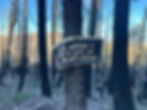
We snacked on cold food, and soldiered on, pausing at Big Bear Creek footbridge crossing to replenish our water supply. When we looked closely, we identified the culprits gathered on the sign.

Lady bugs gathered on the
sign and surrounding debris.
We encountered numerous fallen trees blocking the trail, which slowed our progress, though we completed our day's 12.5-mile segment to an unpaved road junction (mm 1252.7) at 3:45PM.
We attempted to reach mm 1221 in Wrong-way's vehicle via a different route than previously, though were thwarted. We then drove to my car at Bucks Summit, changed plan, again, then drove both vehicles to Three Lakes Campground, 18.8 miles away.
Observing the CLOSED FOR THE SEASON sign and locked gate blocking the campground road, Wrong-way said, "I'm out of ideas. Got any suggestions?"
Stunned, I didn't know what to say, but before I could, he added, "We could drive back to Quincy and get a hotel room."
Exacerbated, I yelled, "F@*%!", realizing that our plan was stymied. Then I added, "Let's find a flat spot here somewhere. No one else will be coming here tonight."
And so, we found a suitable spot to set up Wrong-way's tent, and I told myself that tomorrow would bring a fresh perspective.
10/31/25, Friday (Day 11) - Frost covered everything when we arose. We packed up, drove both cars to Bucks Summit, where I dropped mine. Then, we drove toward Three Lakes/PCT junction (mm 1280.1) in Wrong-way's car. The "four-wheel drive" road to our trailhead connection grew too rough for Wrong-way's vehicle, per his assessment, however, so we parked about one mile short of the Three Lakes trailhead, adding that to our day's NOBO hiking distance (about two miles total). We departed his RAV4 at 10:27AM and reached the PCT junction (mm 1280.1) at 1:30PM. With a temperature of around 47 degrees, and few wispy clouds high above, we remained relatively cool, though my sweat was profuse, as we passed through another section of burned pine forest, which provided little shade.
5PM, we reached my car at Bucks Summit road (mm1269.1).
As I drove us to Belden Town in preparation for our last segment hike of this trip, I told Wrong-way, "I'm bummed about not doing the segment from Feather River to 1221." Prim8 was happy to forego hiking that segment, though.
"I am, too," Wrong-way said.
Wrong-way and I opted for another hotel-stay, this time at the Belden Town Resort & Lodge.
Prim8 was quite content about this, too ... and frankly, so was I! We both desired a break from the aches and pains of knees, calves and feet, which seemed relentless, though varied from day to day.
That evening, Wrong-way and I occupied stools at the resort's bar for drinks and dinner, and in addition, we purchased breakfast burritos for the following morning.
11/1/25, Saturday (Day 12) - Up before sunrise (5:30AM), we consumed our burritos, left the room, and began our hike at the light of dawn.
From Belden Town/PCT junction (mm 1288.0), we faced a SOBO 7.9-mile hike with an elevation differential of 4,013 feet (lowest to highest points) to Three Lakes Summit Trail junction (mm 1280.1). (This segment from mm1267.8 to mm1272.3 gained 3,210 feet!) Though, I knew the "uphill" direction would be fatiguing, I figured that would be more tolerable than the stress upon my knees (resulting in pain) of hiking downhill.
We attained the highpoint along the tail at 11:55AM, awe inspired by the views of the surrounding, rugged terrain.

Feather River canyon near Belden.
(Note: Taken from our day's
hike highpoint.)
We reached the PCT/Three Lakes Trail junction (mm 1280.1) at 12:30PM, officially ending our PCT hiking. However, another 2 miles to Wrong-way's car faced us, which seemed interminable.
Pressed to return home by Monday, Nov 2, Wrong-way mentioned returning at a later date to hike the segment between mm 1221 (near A Tree spring) and the South Fork Feather River junction (mm 1236.5), which he considered an overnight hike.
I admit that 15.5-mile segment (with an elevation loss of 4,200 feet, with a lowpoint near Duck Soup Pond, then a gain of the same elevation to finish, regardless which direction hiked) would be daunting. And, presently, I didn't have the oomph for that.
Once we arrived at my car in Belden Town, Wrong-way and I resorted our respective gear. I removed my Hoka hiking boots. Wrong-way and I bide farewell before starting our respective drives home.
Our final tally: We hiked the PCT, some NOBO and some SOBO, from mm 1196.6 to mm 1221 and mm 1236.5 to mm 1332.3 for a total of 120.2 miles. And we'll return at some point to complete the segment between mm 1221 and mm 1236.5 (15.5 miles).

Prim8 removes his Hoka hiking
boots. (For the last time?)
I opted to head home straightaway and arrived about midnight, relieved that my body could recuperate.
After examining my Hoka's at home, I decided to retire them. I calculated that they'd carried me 353.5 miles on the PCT. I'll probably purchase a pair of their clones, later.

My trusty Hoka hiking boots.
Walk in beauty.


