top of page

You don’t have to save me, you

just have to hold my hand

while I save myself.
Unknown

Blog Posts

As a freelance writer of creative nonfiction, I write to inspire hope for those struggling to heal from trauma. Thanks for reading my posts. If you'd like to read my archived blog posts, use this link.

Writer: Connard Hogan
Connard Hogan
6 days ago
17 min read

Bottom line: Modern medicine can produce some miracles!


I pose at a distance

marker on the PCT.


8/22/26, Saturday (Day 0) - Prim8 and I accompany Wrongway in his RAV 4 to Morgan Hill, where we rendezvoused with Bob N. (Dr. Bobo), our driver/trail support buddy. From there, we continued to a motel in Red Bluff for the night, and hopefully a good rest, before the PCT hike adventure begins near Chester, CA.


Our plan: Dr. Bobo's would provide trail support by driving Wrongway's car. Thereby, we'd enjoy considerable flexibility and camping/meal options, alleviate the need for two sets of overnight gear and the necessity for two vehicles, while cutting down on driving time between trail junctions.


Note: I'll continue to use PCT Halfmile marker designations, though while hiking, I relied on on references from the FarOut cell phone app. Though they don't match, who should expect them to do so? Nothing in life is that simple!

9/23/26, Sunday (Day 1) (NOBO, AKA northbound) - We headed to the PCT trail junction near Chester (mm 1332.3) in anticipation of an early start. About halfway between the two, however, and as if on cue, a deer made an unwise decision...jumped, then paused immediately in front of us. Wrongway had precious little time to react.


BAM! The deer went down.


What?! Primate screamed.


"Came out of nowhere!" I said.


Stunned, we sat in Wrongway's RAV4, as we watched the deer kick and squirm it's way across the road to the opposite side within seconds.


"Mark, is your gun handy?" I asked, considering we should relief a suffering deer of it's misery.


Moments later, the deer rose to it's feet, and began walking towards the rear of the vehicle. I imagined it had an expression of indignation. We were as stunned at that development as we were of the deer's appearance, and our subsequent collision with it.


I turned to face ahead again. "I'm surprised it didn't die immediately," I said.


"Yeah, me, too," Wrongway said.


"The deer hopped the guardrail and disappeared," Dr. Bobo reported.


We checked for damage to the car, and discovered a red fluid leak.


What part of the engine had been damaged?


We questioned, speculated, examined, before continuing on briefly to a flat spot and turnout on the road near buildings on both sides.


"The engine is overheated," Wrongway explained.


Luckily, Wrongway had cell service and called for an emergency tow, which transported us to the nearest RAV4 dealer in Redding, 60 miles away. The dealership repair department wasn't open on Sunday and who knew what needed to be repaired or how long it would take to make the RAV4 drivable?


Wrongway pondered our options. Several hours later, after some consultation with his insurance company, he rented a similar vehicle, and we were headed back to the PCT/Chester junction, our intended starting point.


Dr. Bobo poses aside our rental

vehicle at the PCT/Chester junction.


Beginning our hike early afternoon, under high overcast and in cool temperature, I took the lead, eager to discover if my new Cortisone knee injection would alleviate the agony I'd endured during my last hiking trip.


Our day's objective? PCT mm 1343.1, a day's hike of 10.3 miles, quite ease by PCT hiker standards. The trail started gently, and covered with pumice and dust, led us through a burned section of forest. (See previous photo of the trailhead junction.) Wrongway, wearing shorts, soon realized his choice to be less than ideal, as we pushed our way through waist-high brush bristling with thorns.


"Tomorrow, I'm wearing long pants," he quipped.


Prim8 wasn't complaining, however.


Got nothing to gripe about, dude? How novel! I thought. Fingers crossed, fellow. Left knee doing good. I knew, however, that Prim8 would eventually find something about which to complain...just not sure what and when.


We marched past occasional shaded spots, which grew in frequency as the trail gained elevation. A slight breeze cooled us, and the temperature hovered in the low-80s. The arm stockings, which I'd decided to wear, blocked the sun's rays from my arms and prevented sunburn.


We progressed steadily, then later rendezvoused with Dr. Bobo at 6:50PM (mm 1343.1), before car camping near the trail junction, where a sign claimed the halfway point.


This unofficial sign claims to be at

the PCT halfway point. (My best

guess about 20 miles north of

the official concrete marker.)


8/24/26, Monday (Day 2) (NOBO) - Old Red Bluff Road junction (mm 1343.1) to Chester Warner Valley Road junction (mm 1351.7)


The rental car reloaded with our gear while the temperature hovered the low 50s, before we drove to Chester for breakfast, and cell service so that Wrongway could to attend to car repair issues.


How civilized, Prim8. I'm afraid you'll get spoiled.


Verdict on the RAV4 repairs? It would be several days before parts could be obtained and installed.


We returned to the trailhead (mm 1343.1) where at noon and in pleasant weather, Wrongway, Prim8 and I began our day's hike to Chester Warner Valley Road junction, 8.6 miles away.


Hurt! Prim8 complained of my aching feet in short order.


This is nothing compared to the knee pain during our last hike, Prim8. We'll take care of this later. Then, I noticed pain developing in my left hip area and right ankle, which Prim8 didn't, and wouldn't, overlook. (I'd brought a knee brace, Advil and Bengay, which I hoped would be sufficient to handle any pains that I'd encounter.)


Around mm 1344, we entered Lassen National Park.


We encountered waist-high brush again today and a thick layer of powdery dust blanketed the trail, particularly over the last mile.


Wrongway and I smelled Boiling Spring Lake before we spotted it aside the trail.


"Smells like something burning," Wrongway said.


Stink! Prim8 quipped.


"Kind of like sulfur," I replied.


"Wouldn't want to drink it," Wrongway said, once we eyed the offender.


"Nope, not even if boiled and filtered," I said.


Boiling Spring Lake in Lassen

National Park (mm 1345).


Dr. Bobo awaited our 5PM arrival at the road junction near where we would camp at Warner Valley Campground.


8/25/26, Tuesday, (Day 3) (NOBO) - Chester Warner Valley Road (mm 1351.7) to West Prospect Lookout Road (mm 1364.8)


My 6AM phone alarm set us in motion. I noted a thin, high overcast.


Wrongway reported, "It's 47 degrees."


We left Dr. Bobo and the rental VW at 7:10AM in the cool, calm air as sunrise spread it's colors across the sky.


Soon after, Prim8 kvetched about various pains in my feet.


There's must be a problem with our boots...but, hey, our left knee is doing great! I regretted not buying boots with a wider toe box.


The clouds above filtered the worst of the sun's rays, while my large-brimmed hat and arm sleeves blocked more of it. Meanwhile, the trail remained relatively flat, comprised of small pumice, while a moderate breeze cooled us.


We veered away from the trail at Badger Flat Spring Trail junction for a gentle, cross-country bushwhack to meet Dr. Bobo, who approached on the gravel road 10 minutes later.


We drove to and spent the night at Big Pine Campground, a great campsite, where I had a cozy night's sleep despite the chilled air.


8/26/26, Wednesday (Day 4) (NOBO) - Badger Flat Spring Trail junction (mm 1364.8) to West Prospect Lookout Road (mm 1371.2)


We broke camp starting at 6AM, returned to our rendezvous point of the day before, and started our hike at 7:10AM.


We hiked without difficulty, and along the way, I spotted a deer and non-poisonous snake.


Snake! Prim8 sounded his alarm.


Two long yellow stripes alternated with black along it's length. Don't worry, it's not poisonous, guy.


Lassen Peak.


At mm 1366.5, we passed a sign, which indicated that we were exiting the national park.


We met with Dr. Bobo at our designated spot at 10:15AM. Then, Wrongway attended to his wounded RAV4 in Redding. After a drive to access cell service, he returned to the campground with news that his car was ready for pickup. Options weighed, I accompanied him to Redding to reacquire his vehicle and drop off the rental VW. On our return, we bought a pizza in Burneyand devoured it at our campsite...along with chilled beers.


Wrongway suggested additional revisions in our hike to help maintain our overall schedule. "Let's drive up to the Grizzly Peak area and hike those sections NOBO, but moving to the next section south each day. That would leave us closer (less driving distance) to the section between Chester and Sierra City." (We had an unfinished 15-mile section along that segment which we desired to complete, also.)


Dr. Bob and I were all in.


8/27/26, Thursday (Day5) (NOBO) - Alder Creek Trail junction (mm 1462.1) to the junction with unpaved road 38N53 (mm 1475.2), near Fitzhugh Gulch Creek and the McCloud River.


Up at 6AM, again, in 40-degree air, we packed up, drove as closely as we could (impeded by a locked gate) to Alder Creek Trail junction with the PCT. From there, Wrongway and I worked our way along gravel/dirt road for ~1.5 miles to reach the PCT at 11:30AM, then headed NOBO (northbound) toward our day's destination.


With no intention of spending a night on the trail, and, thus, the approach of nightfall uppermost in our minds, Wrongway and I kept moving as the day progressed.


We can do this, Prim8, if our left knee holds out.


Wrongway and I took a well-deserved lunch about midpoint, then continued on. Prim8, continuously occupied, complained about increasing fatigue and foot pain as I trudged onward mile after mile, on what seemed an eternal downhill grade.


The air humid, and warming, as we lost elevation, I noticed an increase in blood-sucking insects buzzing about and poison oak growing aside the trail.


Careful, Prim8 warned.


Having suffered poison ivy as a child in Kentucky, I've learned to identify the west coast equivalent and am leery of brushing against it. Oh, I'll keep an eye out, dude. And I'm guessing that wherever you find poison oak, mosquitoes won't be far away...and vice versa.


As dusk began to overtake us, Wrongway and I reached our rendezvous point with Dr. Bobo.


"You kicked butt," Wrongway mused, and handed me a cold brewski.


"I thought I could, I thought I could," I replied, surprised that my left knee felt good for a change! Oh, the miracles of modern medicine, Prim8. I alternated between taking a swig of ice cold beer and rubbing the can across my forehead.


We spent the night in a dusty campground. Inches thick, powdery, tan-colored dust, disturbed by the slightest movement, swirled and floated about, before settling on everything.


"You can see the dust in the car headlights," Dr. Bobo noted.


"Yeah. I just wonder how much of that stuff we're inhaling," I said. I noticed that it acted like a stain when I attempted to brush it off my clothing. It just wouldn't come off.


I heard animals bawling in the night, and, soon after, something running down the paved road nearby. I envisioned wild animal(s) rushing headlong through our campsite.


What?! Prim8 blurted. Get run over?


Sounds like a spastic moose, guy. Fortunately, Prim8 and I were spared a stampede.


8/28/26, Friday (Day 6) (SOBO, AKA southbound) - Alder Creek Trail junction (mm 1462.1) to unpaved road junction, 39N10, near Bartle Gap (mm 1447.6)


At 7AM, we arose to clear sky with a cool temperature, and as we broke camp, we talked about the ruckus during the night.


"What caused that noise last night? I thought it was a moose," I said.


"Not around here," Wrongway said. "I looked out and saw several cows, which ran down the road."


Spastic cows, Prim8. "Well, that explains it," I replied.


As we left Dr. Bobo at the car at 9:45AM, he said, "Every step today equals two from yesterday."


Hmm. Though I knew that was intended as an encouragement, I had difficulty adopting that viewpoint as my feet ached.


As expected, Prim8 wailed constantly.


I downed two Advil. That should help, Prim8. Then, I repeated Dr. Bobo's encouraging words like a mantra.


We made steady progress until, at 2:55PM, we met Dr. Bobo who awaited our arrival. From there, we claimed a spot at Dusty Campground near Lake Britton, then headed to Burney for a pizza...and beer.


At camp that evening, I inventoried my feet: blisters under two pinky toes on my right foot; blister aside my left big toe; two sores atop my left foot; and sores on my left pinky. Clearly, my boots weren't doing me any favors. An ample application of medical tape over every blister and sore would have to do...aside from Advil, as needed.


Additionally, in anticipation of rain per the forecast, Wrongway and Dr. Bobo erected their tent rain flies. I used one ground cloth as a makeshift cover over my Bughut, prepared to abandon my ship and take refuge in one of the RAV4's seats. (That vehicle was crammed with our gear, and Dr. Bobo had been resting a small container on his lap most often.)


A drop, or two, of precip may have fallen during the night, though I detected nothing.


8/29/26, Saturday (Day 7) (SOBO) - Bartle Gap area (mm 1447.6) to unpaved road near Peavine Creek (mm 1443.3)


Up at 6AM, my feet and right knee ached, and Prim8 complained.


I'll take two Advil before we start, fella.


In a cool temperature and under clear sky, Wrong-way and I started our day's 13-mile hike at 8:10AM.


The weather remained good and a breeze helped stifle my sweating. Several miles along, we were pushing through overgrown brush/small trees, later we encountered an unobstructed trail amidst an open conifer forest.


A previous back pain returned, an on-going, niggling ache about which Prim8 gave me constant grief.


We'll take Advil, fella. Advil! That's about all we can do. A result of the scoliosis a doc recently diagnosed? Or my day pack without a waist strap? Of course, I didn't have the answer. Perhaps, all of the above. Regardless, I concluded that I had to push on.


Wrongway and I met Dr. Bobo at 3:10PM and proceeded to Butch Dyke Memorial Deer Camp for the night. (Don't ask me if that was someone's actual name...or some sick, perverted joke. I have no idea. A google search has yielded nil, nada, zilch.)


The night air was cold, and I needed the addition of my fleece sleeping bag to keep my feet warm.


8/30/26, Sunday (Day 8) (SOBO)- Peavine Creek area (mm 1443.3) to Britton Lake Dam (mm 1421.8)


Wrongway and I started our hike at 8:20AM, with an ingenious plan to meet Dr. Bobo at unpaved road junction (38N05) after about an 8-mile jaunt. We arrived there at 11:30AM. We rested and ate sandwiches before continuing the remaining 5 miles, or so, to Britton Lake Dam. The sun bore down on us and the temperature was decidedly hotter at 1:45PM, when we reached Dr. Bobo.


Time for a sight-seeing side trip, we visited Burney Falls (photo above), then drove to Burney (the town) for food supplies, ice, more pizza...and beer.


A spot procured in Cave Campground, we set up for the night. Then, Dr. Bobo and I took advantage of the proximity and toured the Subway Cave, a lava tube about one-third-mile in length.


The entrance to the

Subway Cave lava tube.

(Take a flashlight!)


8/31/27, Monday (Day 9) (NOBO) - Mud Lake trailhead (mm 1381.8) to Road 22 (AKA Bidwell) junction (mm 1395.1)


Up at 7AM, we proceeded to the trailhead with another plan to break our day's hike into two smaller segments. The air hazy, with smoke we surmised, all but obliterated a view of Lassen some 39 miles distance. With cell connection and a check of an app, we concluded that several fires in Oregon and the wind direction were likely to blame for the reduced visibility.


I couldn't decide if I smelled smoke, though imagined I did occasionally.


At 8:40AM, we began our hike. The trail ran mostly level and twisting, roughly parallel to the ridge, traversing through chaparral initially, then transitioning to ponderosa.


The full sun, only partially filtered by the haze, beat down upon us. Thankfully, a light-moderate breeze helped keep us cool.


We passed a large water cache, which I guessed to be comprised of fifty one-gallon jugs of water, and with a sign requesting not to post it's location.


Dr. Bobo awaited us at the designated interim meeting point, a dirt/gravel road junction (34N94) (mm 1389.0), where Wrongway and I snacked and rested before continuing on at 12:4PM.


We rested on a wooden bench aside a radio/microwave tower, and enjoyed a hardy chuckle about the letters RIP, which had been carved into the backrest.


Apropos, Prim8?! Though I hoped not so in the more common sense.


My feet ached; Prim8 wailed.


We finished our day's trek at 3:30PM, drove to Old Station, where we obtained the necessary coins to pay for showers.


Not hot! Prim8 demanded.


You got it, buddy. Lukewarm, then cool. After my scrub down, I checked my feet to discover another blister on my left big toe. What do I need to do to prevent this? I concluded that a new pair of boots may be in the offing.


We drove to Burney for another pizza...and beer, then camped at Honne Campground.


9/1/26, Tuesday (Day 10) (NOBO)- Road 22 junction (mm 1395.1) to Baum Lake Road (mm 1408.4)


With more opportunities to meet Dr. Bobo at several interim spots along the way, we began hiking at 8:35AM.


The cooler air, and my arm stockings, helped offset the heat from a relentless sun in a cloudless and much clearer sky.


Our hike went smoothly, aside from Prim8 nagging me about my aching feet.


11:45AM, after an ~7-mile jaunt, we came upon Dr. Bobo at the dirt/gravel road junction (36N07A).


I took opportunity to down an Advil. That should help, Prim8.


Following a snack and rest, we continued. A strong breeze cooled us, and reduced our need to consume water.


Once we'd rendezvoused with Dr. Bobo, we headed to nearby Baum Lake to watch the numerous species of birds resting and feeding there. By chance, a muskrat existed his lair on a mission to collect what appeared to be a twig before returning to it.


Tiny, Prim8 marveled.


A rare treat, Prim8. I'd never seen one up close.


As if by habit, we headed to Burney for pizza...and beer, then, motored to Cassel Campground.


A weather check suggested 1/10-1/4 inches of rain around 2AM, so we battened the hatches with rain flies, a tarp in my case. I steeled myself for a dash to the car, in the event of strong wind scuttling my engineering arrangement.


9/2/26 Wednesday (Day 11) (NOBO) - Baum Lake Road (mm 1408.4) to Britton Lake Dam (mm 1421.8)


I'd heard a few drops of rain through the night, and the ground appeared only slightly affected when we arose at 6AM.


Under an overcast sky, and in the 58-degree air, according to Wrongway, we prepared for our day's hike...to be broken into three segments by meeting Dr. Bobo twice along the way. That plan struck me as sacrilegious for PCT hiking, but what the hay? I took an Advil as precaution against aches/pains.


We left Dr. Bobo at 7:35AM for our first segment, meeting him again at 9:30AM.


Twenty minutes later, we were on our way again. I downed another Advil to dampen my left leg shin pain. To my surprise, my left knee continued to be pain free. We marched on steadily, remaining cool under an overcast of clouds, which threatened rain.


At 12:13PM, we again met Dr. Bobo (our second rendezvous of the day).


Continuing on at 12:50PM, and despite my level-4 shin pain, we finished our day's hike of 13.1 miles, ending at Britton Lake Dam at 13:49PM without encountering rain.


Once in Wrongway's RAV4, small water droplets moistened it's windshield.


"Perfect timing," I observed.


We headed to Old Station, angling for another pizza, if possible. One pie acquired, we drove to Big Pine Campground, where we consumed it along with cold beer.


In the cool air and under an overcast sky, we again anticipated rain during the night. With appropriate preparations completed, i.e., rain flies and trap deployed respectively, we settled in.


I'd lucked out so far, but wondered if my fate would take a turn for the worse. However, though I heard sprinkles at times during the night, everything remained favorable to my staying warm and dry.


9/3/26, Thursday (Day 12) (NOBO and SOBO) - Unpaved West Prospect Overlook Road (mm 1371.2) to dirt/gravel road junction near Highway 44 (mm 1378.3), then Mud Lake junction (mm 1381.8) to Mud Lake trail junction (mm 1381.8) to Highway 44 (mm 1378.3).


Arising at 6AM, we packed gear as light rain coated every exposed surface.


Spared once again, Prim8!


Wrongway and I marched off at 7:01AM, then met Dr. Bobo at the road junction (mm 1378) at 10AM. Then, we drove to the Hat Creek Lookout (mm 1381.5). A moderate, cold breeze blew steadily as Wrongway and I headed southbound and off the ridge toward the valley floor at 10:25AM.


The dismal aftermath of a

wildfire in Hat Creek Valley.

Note the regrowth occurring.


The rain steadily increased, though not enough to drench us, while the wind remained civil.


Though rocks littered a good portion of the trail, and I remained vigilant not to stumble, we moved steadily and achieved our objective by reaching Dr. Bobo at the dirt/gravel road junction near Hwy 44 by 11:55AM.


Celebratory beers all around, we toasted our successful sectional hike from near Chester to McCloud, covering ~143 miles. However, Wrongway and I had to attend to one more detail, a previously uncompleted 15-mile segment between Chester and Sierra City. So...we headed southward to Quincy, CA, with intent to do just that!


We spent the night in a Quincy motel, about which Prim8 reveled.


9/4/26, Friday (Day 13) (SOBO) - Paved Quincy-LaPorte Road, gravel parking area (mm 1236.5) to unpaved road junction near A Tree spring (mm 1221.0)


Following a 4:30AM wake-up, then a 90 minute drive to our starting point, Wrongway and I bundled up in rain gear for the sporadic episodes of light rain and a strong gusting wind. In accord with a weather forecast of rain ending around noon, we started southbound at 6:30AM.


Bundled up to stay dry and warm, I broke into a sweat within the hour. Crap, Prim8! I declined to pause to remove gear. Who knew what rain we would still encounter?


Light rain continued sporadically, and often fell in large drops from the trees that lined the path. My back ached for which Prim8 voiced his displeasure, so I consumed two Advil. Meanwhile, I grew wetter, and at some point, realized that my water proof coat and pants

were failing me...but onward I trekked.


We'll be done when we complete this stretch, fella! That didn't quiet Prim8, though.


Drops of water continued to strike us. Cold wind continued to blow. Our body core was warm while we were moving, however.


We encountered a camouflaged bow hunter, who stated that he abandoned his day's plans due to strong, cold wind at the exposed ridge ahead.


No! Prim8 wailed.


We'll just need to keep moving, dude. As long as we are warm enough, we'll be okay. Well, "warm enough" were the salient words! My hands, face, and feet were chilled to the bone. It crossed my mind that frostbite may result, at least in my toes, which squished water with every step.


Indeed, the wind blew hard along the ridge trail. But I continued to move forward, soaked, achy, fatigued and miserable.


About halfway along, Wrongway and I paused for 10-15 minutes to replenish our energy. I downed two Advil. Wrongway offered to loan me his rain jacket, but I declined. At some point, he noted that the lowest temperature for the day had been 40 degrees.


"As long as I keep moving, and the wind doesn't blow a gale, I'll stay warm and be okay," I said, fingers crossed.


I worked to keep pace, despite my fatigue, miserable condition and continued back pain, generally zigzagging down the trail like a drunken sailor. Wrongway commented that he'd noticed me staggering and hunching over, which I couldn't dispute.


We continued on, me going as fast as I could manage.


Several miles on, Wrongway offered to carry my back. "I've got the energy, and want to finish our hike as soon as we can," he said.


I was in no condition to argue his point, so relented. He'd made a good point. I was slowing our combined progress.


Though time dragged on as I plodded down the trail, we reached the RAV4 and Dr. Bobo at 2:50PM.


Feeling like a soggy dishrag, and Prim8 eager to warm up inside the RAV4, I told Wrongway and Dr. Bobo, "Well, THAT (emphasis added)...was a miserable fifteen miles."


Once again, however, congratulations were in order. Finally, Wrongway and I had completed a previously missed segment, and now had hiked the PCT from near Sierra City (mm 1191.6) to Etna Summit (mm 1581.0), a total of 390.4 miles...or thereabouts.


We drove to Sierra City...had to...in order to introduce Dr. Bobo to Sorracco's Saloon, and where I could indulge another Kentucky Tangerine Cream Ale (beer).


Prim8 was beside himself with anticipation.


And alas, we consumed cold brews at Soccarro's. Me? I relished a Kentucky Tangerine Cream Ale, and then a Kentucky Vanilla Barrel Ale, while Prim8 went to hog heaven. Afterward, we spent the night at the Old Sierra City Hotel.


9/5/26, Saturday - We drove to Morgan Hill, dropped Dr. Bobo at his car, exchanged our farewells, then Wrongway and I headed to Gilroy to spend the night before our return home on Sunday.


Previous lesson learned, I've scheduled a left knee replacement. As well, I've acquired a new rain jacket and pants, and will contemplate purchasing new boots!


Miracle of miracles, the cortisone injection had eliminated my knee pain. And, two sections of the PCT completed (Mexico to Cottonwood Pass, and Sierra City to Etna Summit), Wrongway and I have hiked roughly 1,139 miles of the PCT. Though not quite half of it's total length, we've made a good showing...so far. Fingers crossed!


Walk in beauty.


Writer: Connard Hogan
Connard Hogan
Nov 8, 2025
10 min read

Bottom line: The best laid plans often go astray.


Sunset near Quincy, CA.


Mark R. (once again using the moniker of Wrong-way) and I made a last minute alteration to our hike plan (the section from Horseshoe Meadow to Bishop Pass). Instead, we opted for a stretch of trail in lower elevation, and thus, with less chance of inclement weather, vis-à-vis snow. Wrong-way liked the section between Sierra City, CA (mm 1196.6) and Chester, CA (mm 1332.3).


Note: Though, we opted to hike northbound (NOBO) some days, and southbound (SOBO) some days, I provide the northbound mile-marker designations for consistency, since we're headed northward overall anyway.


And, as per our two-vehicle availability, we anticipated moving our cars as necessary to maximize our one-day hikes, decrease the number of overnights on the trail ... and thus carry less weight (tent, sleeping bags, water, warm weather clothing and food). In addition, we'd have the option to hike northbound or southbound, depending which direction we considered the most advantageous for each section between our positioned vehicles at road junctions (increasing or decreasing elevation, for example). What a plan! Thru-hikers can't do that! Prim8 was all in on the idea, of course.


10/20/25, Monday (Day 0) - Wrong-way and I rendezvoused in Chester, a drive of some 538 miles for me, for an overnight stay there prior to starting our segment hiking. My drive went smoothly and the fall colors of deciduous trees near Lassen National Park were stunning, which helped offset the depressing and seemingly endless burned, blackened pines.

10/21/25, Tuesday (Day 1) - Frost coated my car's windshield in Chester as Wrong-way and Prim8 anticipated beginning our first day's segment hike.


My car positioned at Highway 36/PCT junction (mm 1332.3), we then drove to Humboldt Summit parking area (mm 1312.8) in Wrong-way's car.


Starting our hike at 8:30AM under a cloudless sky and temperature of 36 degrees F, I anticipated feeling chilled as we headed NOBO (northbound), though soon warmed up as per usual from the exertion of hiking.


To my surprise, we came upon the PCT "Halfway Monument" (mm 1320.7). (Due to yearly reroutes, however, the actual halfway point is now estimated to be closer to mile 1325.1.) Though, Wrong-way and I had skipped a considerable section of the PCT from Horseshoe Meadow to here, we nevertheless commemorated our arrival. After all, we fully expected to hike every mile of the trail at some time, regardless.


Prim8 points NOBO from

the PCT Halfway Marker.


I spotted a sticker inside the registration box at the Halfway Monument, and pointed it out to Wrong-way. We both chuckled.


"I go through this every day," I joked to Wrong-way. Prim8 knew exactly what I meant.


Sticker on the registration box

at the PCT Halfway Monument.


Several miles on, we passed two men engaged in trail maintenance. One informed us that the Dixie Fire had consumed about 980,000 acres in 2021. Note: I've since researched that fire and learned it burned for two months, reached a final size of 963,309 acres (that's 1,505 square miles!) and was the second-largest single wildfire in California history at the time.


Wrong-way (Mark) pauses

on the trail. (Note: We were to

see many burned pine trees.)


A view of burned pine forest with

Mt. Lassen (background, near centered).


A better view of Mt.

Lassen from the trail.


Further evidence of a fire.


Evidence of forest regeneration.


We camped near Soldier Creek at mm 1325.4, some 12.6 miles from our start. Then, we munched on cold, dry food. No cooking on the trail for us! We avoided schlepping cooking gear, stove and fuel on the trail. Why carry the weight?


10/22/25, Wednesday (Day 2) - The temperature a bit warmer, and with no frost present at 8:11AM, we continued NOBO in light wind through the remnant of burned pine forest.


I noticed a familiar pain aside the heel of my left foot as we hiked. Sure enough, when I checked later, I discovered a blister.


Dang it, Prim8! I won't forget to grease my feet again.


Once at Highway 36 junction (mm 1332.3), we drove to Belden Town to drop my car, then headed to Humboldt Summit parking area in Wrong-way's RAV4.


10/23/25, Thursday (Day 3) - Under clear sky and in a light, but chilling breeze, we left our car camp at Humboldt Summit at 7:30AM, heading SOBO. Before we started, however, I'd applied a pad to my foot's blistered area, then smeared an ample amount of Vaseline to both feet. (And which I would continue to do daily.)


That should fix it, Prim8.


Low growing brush, from one to one-and-a-half feet high, crowded the trail for several long stretches.


No place to be wearing short pants, Prim8!


At ~mm 1300, a sign informed us of the transition boundary from the Cascade Mountain Range to the Sierra Nevada Mountain Range. Soon after, I concluded the trail condition had worsened when the rounded, smaller pumice stones disappeared, replaced by irregular, jagged ones of various composition that created a greater tripping hazard!


At 6PM, as nightfall approached, and unable to find a nearby designated trail campsite, we discovered a level area aside the trail, large enough for the footprint of Wrong-way's two-man tent (~mm 1296.6?).


Can you spot our

makeshift campsite?

(BTW, we left no discernible

traces of our presence.)


10/24/25, Friday (Day 4) - Breaking camp, we continued SOBO at 7:51AM. Prim8 complained constantly about knee pain as we hiked this 8.6-mile rocky stretch descending nearly 2,600 feet in elevation, though not at a steady grade. Slowed by the agony of painful knees (mine), we arrived at my car in Belden Town (mm 1288.0) at 1:30PM.


Wrong-way prepares to peruse the

"dubious luxuries" at the Belden

Town Resort Lodge.


After retrieving Mark's car, we discussed various options, revised our plan, then drove both vehicles to a hotel in Chester.


Blame it on age, or poor physical conditioning ... and though I had thoughts of becoming a wuss ... I put up no fuss when Wrong-way had suggested this option. I preferred to blame it on my painful knees! Prim8 wasn't complaining, that's for sure.


10/25/25, Saturday (Day 5) - During an intermittent light rain in Chester, we enjoyed a cooked breakfast at Cravings Restaurant. Sated for the moment, we prepositioned my car at Bucks Lake Road junction (mm 1269.1), then drove Wrong-way's vehicle to Big Creek Road junction (mm 1264.7).


Dressed for rain, our 4.6-mile trek to my car proceeded in relatively dry conditions, though the sky broke open just as we finished our hike.


Great timing, Prim8! "Just in time," I joked with Wrong-way.


We retrieved Mark's RAV4, and made a beeline for the Old Sierra City Hotel, where we secured a room.


Prim8 embraces the Old

Sierra City Hotel as

"Home, Sweet Home."


Restroom sign at Old Sierra

City Hotel, least anyone get

confused.


Wrong-way and I sauntered down the double-lane main street (the only street there that I could discern) to Sorracco's Saloon, less than a hundred yards distance. With a considerable selection of beer and liquor from which to choose, we sampled some of Ron's wares, as we chatted with him and other fellow imbibers.


My selection of a "Kentucky Tangerine Cream" beer hit the spot. Very tasty it was, and Prim8 loved it! That encouraged me to imbibe with a shot of Mary Dowling bourbon ... though I'm not a connoisseur by any means, I just like to experience different things. Wrong-way stuck with beer.


Returned to the Old Sierra City Hotel, we had dinner, then hunkered in for the night.


10/26/25, Sunday (Day 6) - Rain continued throughout the day. (Would've been a misery for us to hike). Anticipating the weather's improvement, we'd positioned Wrong-way's car at a campground (mm 1221) near "A Tree spring". (I kid you not about that name.) One rough patch on the road nearly stymied us altogether, when I had difficulty getting traction over an formation of rock. Persevering, however, I maneuvered my car to the planned trail/campground junction. Then, leaving Wrong-way's car there and on our way out in my car, Wrong-way strategically re-positioned a few rocks, which helped reduce the severity of the said obstacle, and thus, potential damage to my vehicle.


We returned to the Old Sierra City Hotel for another night's stay.


10/27/25, Monday (Day 7) - The rain moved on, and the sky was cloudless, though the roads remained wet and a thin layer of snow covered the ground in scattered patches. In my car, we drove to a jeep road/trail junction (~mm 1208), which Wrong-way referred to as "Packer Lake", though that name didn't appear on the Halfmile PCT notes.


I wrapped my soar, left knee with a stretchy bandage, and we started our hike SOBO about 9:25AM in a temperature of 37 degrees F. An intermittent light breeze kept us cool. Small amounts of snow lay spread across the terrain and on the trail, clearly recording evidence of bear presence, as our day's hike segment ranged above seven-thousand feet.


Evidence of bears in the vicinity.


When we completed our day's hike in Sierra City, Wrong-way and I opted to stay at the Old Sierra City Hotel ... again!


Are we turning into wimps? I wondered. Prim8 liked the idea, however. I concluded that the stretchy bandage worked to reduce my left knee pain, and that hiking uphill might better suit my body.


10/28/25, Tuesday (Day 8) - Up at 6AM, we drove to mm 1208 (Packer Lake), then started our SOBO hike toward Sierra City (mm 1196.6) at 7:10AM in the 33-degree temperature. Initially, needle ice on the trail crunched under our feet, though disappeared as the sun warmed the air.


The trail gained elevation, as we circumnavigated the Sierra Buttes, then crossed the rock breakdown below the buttes.


Worried about tripping, resulting in a face plant, Prim8 thoroughly disliked this section ... and I agreed.


Segment of PCT which

I named "the slag heap".


"That was a real slag heap," I commented to Wrong-way afterwards.


Once at Wrong-way's RAV4 near Sierra City, we attempted to reposition it to the South Fork Feather River/trail junction (mm 1236.5). However, over-grown brush created a ever-narrowing corridor along the unmaintained road, before a fallen tree blocked our path altogether.


"Close, but no cigar," I said to Wrong-way.


He backed his car through the embracing brush about one-hundred feet before reaching a suitable spot where he could turn around.


At dusk, we car-camped at a road/trail junction (mm 1236.5).


10/29/25, Wednesday (Day 9) - We left Wrong-way's vehicle at 7:40AM, hiking NOBO under clear sky. Despite the cool temperature in the shade, I sweat profusely. We encountered fallen trees, necessitating a clamber over or an off-trail diversion around.


Prim8 whined about my tired, aching feet. I commiserated.


We crossed the steel bridge over the Middle Fork Feather River (mm1250.9).


Prim8 pauses for a better look.


Continuing onward, we passed what I considered a wizened tree.


Fungus on a burned pine.

(Wizened? Judge for yourself.)


At our day's hike of 16.2 miles, we arrived at a trail campsite (mm 1252.7).


10/30/25, Thursday (Day 10) - I'd had a long, miserable night as my legs ached. However, I forced myself up for a 7:20AM start, despite Prim8's protests.


We snacked on cold food, and soldiered on, pausing at Big Bear Creek footbridge crossing to replenish our water supply. When we looked closely, we identified the culprits gathered on the sign.


Lady bugs gathered on the

sign and surrounding debris.


We encountered numerous fallen trees blocking the trail, which slowed our progress, though we completed our day's 12.5-mile segment to an unpaved road junction (mm 1252.7) at 3:45PM.


We attempted to reach mm 1221 in Wrong-way's vehicle via a different route than previously, though were thwarted. We then drove to my car at Bucks Summit, changed plan, again, then drove both vehicles to Three Lakes Campground, 18.8 miles away.


Observing the CLOSED FOR THE SEASON sign and locked gate blocking the campground road, Wrong-way said, "I'm out of ideas. Got any suggestions?"


Stunned, I didn't know what to say, but before I could, he added, "We could drive back to Quincy and get a hotel room."


Exacerbated, I yelled, "F@*%!", realizing that our plan was stymied. Then I added, "Let's find a flat spot here somewhere. No one else will be coming here tonight."


And so, we found a suitable spot to set up Wrong-way's tent, and I told myself that tomorrow would bring a fresh perspective.


10/31/25, Friday (Day 11) - Frost covered everything when we arose. We packed up, drove both cars to Bucks Summit, where I dropped mine. Then, we drove toward Three Lakes/PCT junction (mm 1280.1) in Wrong-way's car. The "four-wheel drive" road to our trailhead connection grew too rough for Wrong-way's vehicle, per his assessment, however, so we parked about one mile short of the Three Lakes trailhead, adding that to our day's NOBO hiking distance (about two miles total). We departed his RAV4 at 10:27AM and reached the PCT junction (mm 1280.1) at 1:30PM. With a temperature of around 47 degrees, and few wispy clouds high above, we remained relatively cool, though my sweat was profuse, as we passed through another section of burned pine forest, which provided little shade.


5PM, we reached my car at Bucks Summit road (mm1269.1).


As I drove us to Belden Town in preparation for our last segment hike of this trip, I told Wrong-way, "I'm bummed about not doing the segment from Feather River to 1221." Prim8 was happy to forego hiking that segment, though.


"I am, too," Wrong-way said.


Wrong-way and I opted for another hotel-stay, this time at the Belden Town Resort & Lodge.


Prim8 was quite content about this, too ... and frankly, so was I! We both desired a break from the aches and pains of knees, calves and feet, which seemed relentless, though varied from day to day.


That evening, Wrong-way and I occupied stools at the resort's bar for drinks and dinner, and in addition, we purchased breakfast burritos for the following morning.


11/1/25, Saturday (Day 12) - Up before sunrise (5:30AM), we consumed our burritos, left the room, and began our hike at the light of dawn.


From Belden Town/PCT junction (mm 1288.0), we faced a SOBO 7.9-mile hike with an elevation differential of 4,013 feet (lowest to highest points) to Three Lakes Summit Trail junction (mm 1280.1). (This segment from mm1267.8 to mm1272.3 gained 3,210 feet!) Though, I knew the "uphill" direction would be fatiguing, I figured that would be more tolerable than the stress upon my knees (resulting in pain) of hiking downhill.


We attained the highpoint along the tail at 11:55AM, awe inspired by the views of the surrounding, rugged terrain.


Feather River canyon near Belden.

(Note: Taken from our day's

hike highpoint.)


We reached the PCT/Three Lakes Trail junction (mm 1280.1) at 12:30PM, officially ending our PCT hiking. However, another 2 miles to Wrong-way's car faced us, which seemed interminable.


Pressed to return home by Monday, Nov 2, Wrong-way mentioned returning at a later date to hike the segment between mm 1221 (near A Tree spring) and the South Fork Feather River junction (mm 1236.5), which he considered an overnight hike.


I admit that 15.5-mile segment (with an elevation loss of 4,200 feet, with a lowpoint near Duck Soup Pond, then a gain of the same elevation to finish, regardless which direction hiked) would be daunting. And, presently, I didn't have the oomph for that.


Once we arrived at my car in Belden Town, Wrong-way and I resorted our respective gear. I removed my Hoka hiking boots. Wrong-way and I bide farewell before starting our respective drives home.


Our final tally: We hiked the PCT, some NOBO and some SOBO, from mm 1196.6 to mm 1221 and mm 1236.5 to mm 1332.3 for a total of 120.2 miles. And we'll return at some point to complete the segment between mm 1221 and mm 1236.5 (15.5 miles).


Prim8 removes his Hoka hiking

boots. (For the last time?)


I opted to head home straightaway and arrived about midnight, relieved that my body could recuperate.


After examining my Hoka's at home, I decided to retire them. I calculated that they'd carried me 353.5 miles on the PCT. I'll probably purchase a pair of their clones, later.


My trusty Hoka hiking boots.


Walk in beauty.


Bottom line: Getting back to your roots can be a spiritual experience!


Sunset from Hwange

National Park, Zimbabwe.


Janet and I recently joined a Smithsonian Journey to South Africa, Zimbabwe and Botswana, places we'd never been. Though a short trip in duration, our itinerary kept us busy as beavers, and we were filled with great memories of encounters with a wide spectrum of wild animals ... up close, that is. In addition, we were treated to three lectures by Dr. Robert Schrire about South Africa's apartheid past, it's current political environment and potential future. And, it should go without saying, we took necessary precautions against illnesses, for example by dosing ourselves with a generic version of Malarone to ward off malaria.


Thursday, Oct 2 (Cape Town, South Africa) – We spent a "free day" before our tour activities began in earnest by touring several nearby wineries.


Friday, Oct 3 (Cape Town) – After an orientation meeting, we toured the peninsula south of South Africa's "mother city".


1) Cape Town was originally establish in 1652 as a "rest and resupply stop" by the Dutch for ships rounding Africa's southern cape.


2) The Chinese were visiting and charting that shoreline as early as 1421!


3) Along our drive, we learned that one of the local wines is named "Splattered Toad", originating from toad road kill, a result of migrating creatures crossing roads during egg-laying season.


The tip of the Cape of Good Hope.


4) Originally named Cape of Storms by Bartolomeu Dias in 1488, the cape was renamed by King John II of Portugal in order to encourage the poor wretches rounding Africa on the ships.


5) Ironically, the Cape of Good Hope is not the most southern tip of Africa. Cape Agulhas, east and 34 miles farther south, owns that distinction, and many ships mistook the Bay of False Hope as their route of passage to Europe.


False Bay (distant left) and Cape

of Good Hope (below the right peaklet).


6) South Africa has eleven official languages, respecting the various tribes and subsequent immigrants, such as the Dutch descendant Afrikaners, and the English. Remember the Boer War between England and the Dutch settlers? (Though apparently, there were two!)


Headed back to Cape Town via the western side of False Bay, we stopped at Boulders Beach to view a colony of African Penguins.


One of the many penguins at the

colony approaches viewers without

concern. (BTW, that's sand, not snow!)


Saturday, Oct 4 (Cape Town) – We headed to Robben Island via ferry from Cape Town Harbor.


Cape Town Harbor

and Table Mountain.


We toured Robben Island, used as a prison location and leper colony off and on from1683. A former political prisoner provided us a guided tour of the facility, including Nelson Mandela's cell.


Nelson Mandela's cell.


After returning to Cape Town, clouds obscured Table Mountain, so we drove to Signal Hill, adjacent and lower, though clouds hampered panoramic views from there, as well.


A portion of Cape Town from the

flank of Signal Hill. (Our hotel,

pink, is roughly centered.)


Sunday, Oct 5 through Tuesday, Oct 7 (Kapama Private Game Reserve) – We flew to tiny Hoedspruit airport near Kapama Private Game Preserve. And, while staying at the lodge, we were treated two "Game Drives" daily, several hours each morning and each evening. And, we started living an African wild-game National Geographic documentary, rather than watching one on TV!


Riding in specially adapted jeeps during our six Game Drives, we witnessed a multitude of animals.


7) We were warned to remain seated (as well, by no means leave the vehicle), and if we didn't yell or make wild gestures, the animals would consider us as part of the jeep ... and, that the animals, having never been threatened or harmed in association to the jeeps, would not react with alarm or fear. And, so it was!


A stately male Cape Buffalo.


A leopard!


Family herds commingle

at a waterhole.


A male lion heads for a snack.


Same lion snacks on a giraffe.


Hippos in their element.

(What's so funny?)


8) Except to eat, hippos do almost everything in the water, where they keep cool, and protected from predators and the sun's harsh UV-rays.


Warthogs (Eating what?)


I couldn't determine what they were so interested in!


Two giraffes, in no hurry.


11) Giraffes browse on the straight thorns of Acacia trees, which are modified leaves. (We were warned not to feed a giraffe as the tongue could rip the skin from your hand!)


12) Giraffes have the highest blood pressure of land animals ... 220/180 mmHg when standing, but can rise to 330/200 mmHg when drinking water. Gotta move that blood up and down a long neck!


Our guide drove us to a hyena den. (All the guides knew where that hyena den was located, and it's not like the hyenas move everyday!) And, with luck, we observed an adult pair with two young during siesta.


Hyenas, unfazed by our presence.


A Red Hornbill.


Vervet Monkey with baby perches

on the roof of our resort lodge.


We saw no African wild dogs, though they do roam into the preserve as they have an expansive range. As well, they are the rarest (most endangered) of the land animals there.


13) Though not the fastest of land animals, reaching a speed of 70 kph (43.5 mph), wild dogs have considerable endurance and tire their prey prior to attack, figuratively running them into the ground.


Though we didn't see the termites, their mounds are indeed impressive.


Active termite colony mound.


14) Termite queens can live up to 50 (fifty) years!


Wednesday, Oct 8 (Johannesburg) – After flying to Johannesburg, we drove to an impoverished township Kliptown, located in Soweto (short for South Western Townships). On the way to Kliptown, we stopped for lunch, where I enjoyed a locally brewed beer.


Houses in Kliptown (Soweto).


Then, we were driven to our hotel in Johannesburg for an overnight stay.


Thursday, Oct 9 (Pretoria) – After our overnight in Johannesburg, we were driven by bus to the Rovos Rail Station in Pretoria.


Panorama of the Rovos Rail "Capital

Park Station" (Maintenance Yard far left).


Rohan Vos, owner of Rovos Rail, gives

us a tour of the Maintenance Yard.


He explained that he purchases dilapidated train cars and refurbishes them in the style of former luxury-travel glory-days. Following our guided tour, we had lunch at the station. Originally, we were to board the Rovos Rail train there. However, that plan got "derailed" when a train mishap along the line blocked the track. So, we boarded buses, and were driven to Louis Trichardt, some 234 miles "up the line" in order to by-pass the blocked rail section.


Janet and I ready to board

the train in Louis Trichardt.


Our original compartment on the train, more of a cubicle, would've likely resulted in "murder on the Rovos Express", as Janet and I later joked to others ... and, as luck had it, we upgraded to a larger compartment.


Janet in our compartment upgrade.


We settled in for our three-day train ride, rocking and rolling, as well as jerking forward and backward without prior notice, when the train stopped and started. Such are the joys of train travel in some parts of the world! Regardless, we soaked in the train's Victorian/Edwardian ambience of luxury as best we could.


The more regal of the two dining cars.


Janet poses in the

Observation Car (aka bar).


Friday, Oct 10 (Rovos Rail) – The train rumbled along as we crossed the border into Zimbabwe, near Beitbridge,


15) then traveled one of the longest straight stretches of track in the world, 114 km (71 miles).


Saturday, Oct 11 (Rovos Rail) – Our train stopped at Hwange National Park, Zimbabwe, and we enjoyed another Game Drive, observing more animals.


An infant baboon tentatively

explores the world.


Grazing Wildebeest.


Jackal. On the hunt?


Two Zebra leave the waterhole.


Following our Game Drive, we re-boarded the train for Victoria Falls ... and, sometime in the night, I developed a case of "Montezuma's revenge"!


Sunday, Oct 12 (Victoria Falls) – We disembarked the train at Victoria Falls Station, and checked into our hotel. I informed our tour guide, Tina, of my malady. She suggested the cause was a side-effect of my antimalarial medication, and gave me several carbon pills to take, which I did. (Janet had similar symptoms, though I'll not elaborate further!)


The Rovos train awaits it's next

passengers at Victoria Falls

Station across from our hotel.


Though feeling weak from loss of body fluids and sleep, I soldiered onward as we took a walking tour of nearby Victoria Falls, which provided us gorgeous views.


15) The falls border Zambia and Zimbabwe,


16) and are just over a mile wide when the Zambezi River flows in abundance.


The falls from the Zimbabwe

side at the end the drier season.


Monday, Oct 13 (Chobe National Park, Botswana) – Feeling much better, I'd once again prevailed over Montezuma. By bus, we were driven to the border check point, then walked through "no-man's land" into Botswana. In Chobe National Park, we climbed into a jeep for another Game Drive, then later boarded a boat for a ride on the Chobe River to see the wildlife from a different perspective.


A "journey" of giraffes

cross a Game Drive road.


17) Our game driver told us when stationary, they're referred to as a "tower"!


The Chobe River from

our Game Drive jeep.


A "committee, venue, or volt"

of vultures. (Take your pick!)


I prefer committee. Maybe, it's my suspicious nature, but I think they were conspiring!


18) If those vultures were eating, they'd be called a "kettle"! (Who thought that up?)


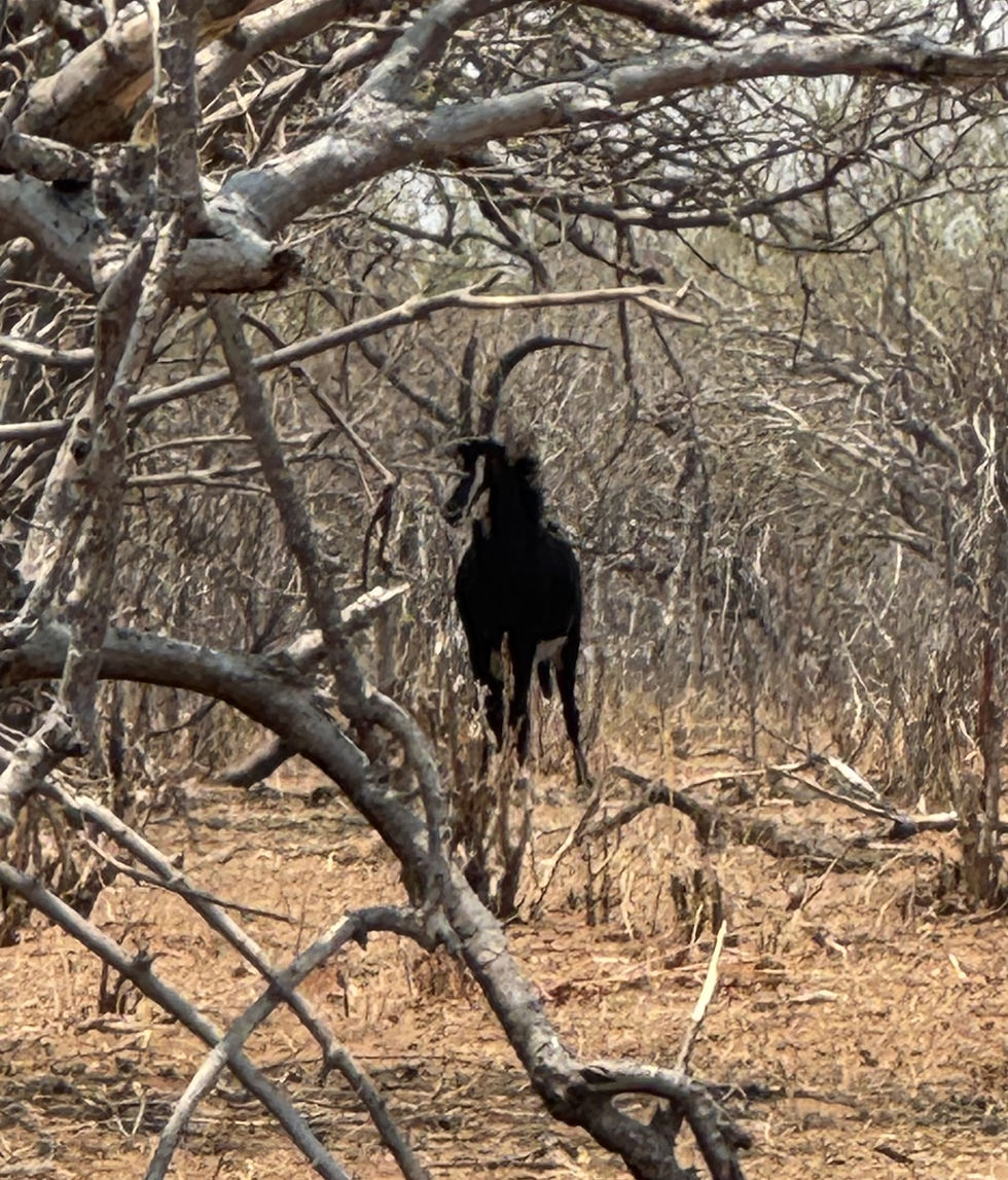
A male African Sable (antelope).


I always thought sables were smaller furry things! Aside from that, we saw animals I'd not previously heard of, such as Kudu, Tsessebe, Puli and Red Lechwe (all ungulates), not to mention the numerous winged critters.


Tsessebe headed away from the river.


19) We were informed that Tsessebe are among the fastest land animals, reaching speeds up to 56 mph, as opposed to cheetahs at 70 mph.


Guinea Fowl (aka Chobe Chicken).


Our game driver told us Chobe Chickens are tougher and not as tasty as our more common American tamed fowl of that name. (I took his word for it!)


A male Kudu checks us out.

(Impalas graze behind him.)


An Openbill Stork (African

variety) looks for a meal.


Chobe National Park proved to be a birder's paradise. I couldn't keep up with all the names of the birds we saw, much less snap photos of them.


An elephant snorkels across the Chobe

River in search of greener pastures.


We spotted two hippos grazing in the morning, which they sometimes do in order to beat the other grazers to the best stuff. Competition, you know!


Two grazers, unconcerned

about our presence, munch away.


20) Hippos graze on short grass,


21) can travel up to 6 (six) miles per outing, and,


22) with tusks instead of smaller teeth, they use their specially adapted lower lip to graze.


A mother crocodile guards

her egg nest on a small island

created by the Chobe River.


Soon after I captured this photo, another boat approached her to within several feet, and she didn't flinch! Our boat guide said she wouldn't move unless her eggs were threatened.


After our day's excursions, we were treated to local entertainment during dinner at our hotel.


Our evening's dinner entertainment

at Victoria Falls Hotel.


Tuesday, Oct 14 (Homeward bound) – Our African safaris come to a close, we flew to Johannesburg, then home via Dubai, arriving early evening Wednesday our local time.


I thoroughly enjoyed our safari adventures in Africa, found them informative, enlightening and enriching. I'd recommend travel there to anyone, particularly near the end of the dry season. (Hint: fewer mosquitoes and less tree leaves to obstruct spotting animals.)

May you enjoy your adventures and walk in beauty.


You can email me:

connard@connardhogan.com

Subscribe to My Quarterly Newsletter

Thanks for subscribing!

Top of page

Background Photo Credit: Nick Kwan/Pexels

© 2023 by Connard Hogan. Proudly created with Wix.com

bottom of page